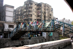
Dharavi is a heart-shaped agglomeration of primarily informal settlements at the heart of Mumbai, India, with over 800,000 inhabitants. As a highly dense place with commercial and residential units located at the very edge of roads (and sometimes contesting them), river branches and drainage canals, connectivity amongst the nagars and movement of people is not always easy. Even though main streets are clearly defined, the inner pathways and small streets born as a result of random growth of residential/commercial areas within nagars are disposed randomly and a great number of them culminate in dead-ends.
Considering this, the intervention proposed aims to respond to part of these issues by focusing in the creation of connectivity links, apart from the already existent ‘Mahim Phatak Road’, ‘60 feet road’, and ‘90 feet road’, from and to the railway station; more specifically, this proposal focuses, mainly, on the connectivity along the ’60 feet road’ which is limited by the drainage canal, which runs beside it, and does not facilitate pedestrian transit apart from one little precarious bridge made of pipes and other scrap material.
The intervention is about bridging communities between the ‘13 compound’, ‘Along Western Railway’, ‘Muslim quarter’, ‘Kunji Kuerne Nagar’ and ‘Koligaon/Agarwada/Rajivindira’ nagars, enabling people to access them more easily.
“Successful development depends on good access and connections. The connections between a site and its surroundings are important for even the smallest of developments.” Urban Design Compendium (p.28)

